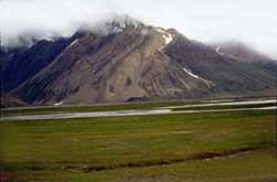
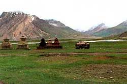
Rangdum - The farthest and most isolated part of the Suru valley, Rangdum (3657 m) is surrounded by colourful hills on the one side and glacier-encrusted rocky mountains on the other. Situated 130 kms south-east of Kargil, it falls midway between Kargil and Padum.
Visitors to Padum (Zanskar) generally prefer to break the gruelling 240 km-long road journey for an overnight halt here. Set amidst spectacular surroundings, Rangdum is a convenient area for camping in the Himalayan wilderness while being sufficiently near a roadhead. In the late afternoon the setting sun lends the valley an ethereal ambience, as the ochre hills turn aflame, while the snow covered peaks sparkle with a reddish hue in the distant horizon.
 |
|
The main attraction of Rangdum is the 18th century Buddhist monastery of the Geluks-pa order with about 40 resident monks. Perched picturesquely atop a central hillock, which is surrounded by a wild mountain stream, the monastery has the aura of an ancient fortification guarding a mystical mountain valley. Its central prayer hall houses an array of figures and art objects. Two small hamlets surrounded by rows of chortens, Yuldo and Tashi-Tongze, situated on either side of the monastery, are the only other habitations in the area. The inhabitants of these villages are descendants of the monastery's agricultural serf-tenants, who do not own any land in the region. The monastery enjoys perpetual and unalienable ownership of the entire valley, including the fields tilled by the villagers, the pastures, hills and even the streams.
| |
 |
Rangdum is also an important trekking base. The most popular trek from here leads to Henaskut on the Kargil-Leh highway, across the Kanji valley gorge. This 5-day trek is also the last leg of the 2-week long trans-Himalayan traverse between Kashmir and Ladakh. Among the shorter treks possible from here, the best is a hike up the Penzila Ridge, to camp for a night or two opposite the majestic Drang-Drung Glacier.. The trek to Shafat valley where the Nun-Kun base camp is situated, involves walking down valley, along the road to the campsite of Gulmatongo (20 kms), and thence crossing the Suru River on a foot bridge to enter the Shafat Nallah, upto the snout of the Shafat Glacier for camping. |
